 Spey Bay Viewed Across the Mouth of the River Spey |
Since this page was produced, the route of the Speyside Way at its south-western end has been extended from Aviemore to Newtonmore and the spur to Dufftown has been deleted. You can find out more from the official website, linked from the visitor information section of this page, or from the Rucksack Readers guide, which we reviewed here. We aim to update this page as soon as possible.
The Speyside Way links the sea at Buckie with the Cairngorms at Aviemore and at Tomintoul. The main path between Buckie and Aviemore is 65 miles long and tends to follow the course of the River Spey. There are also two spurs off the main path, of 15 miles to Tomintoul and of 4 miles to Dufftown.
The central parts of the Way opened in 1981, with the Tomintoul spur following in 1990. The last five miles from Spey Bay to Buckie opened in 1999, and the southern section to Aviemore completed the Speyside Way in April 2000. There are plans to extend the Way south to Kingussie and Newtonmore: with the possible line of the proposed extension shown in lighter grey on the map. The section as far south-west as Kincraig opened in September 2015.
There are those who feel the Speyside Way should be walked from the coast to the mountains, which allows you to tackle the easier parts of the route first. Our own preference is to start in Aviemore and progress north-east to Buckpool. This means you tend to be walking away from the sun rather than towards it: and we like the idea of following the flow of the River Spey rather than walking upstream. But the joy of walking is the freedom to choose for yourself.
The side column gives links to useful resources. The route description below is broken into seven main sections, each of which would make a fairly easy day's walking: and each of which contains links to further information on Undiscovered Scotland. The Area Pages provide links to accommodation providers and other businesses. The Feature Pages each contain detailed background information and a collection of images about particular places or attractions on the Speyside Way or near it.
Note that this page does not set out to provide you with the full range of detailed information you need to walk the Way, but it should give you a good starting point. And when used with the rest of Undiscovered Scotland it will give you a clear idea of what the Speyside Way and the places you will be passing through are like.
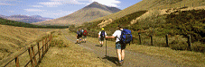
Section 1: Aviemore to Boat of Garten, 6 Miles
Aviemore is well served by public transport: especially by train as it lies on the main line to Inverness. We've assumed a short first day's walking after a journey to Aviemore. An alternative is to combine the first two sections described here: another to commence your trip to the sea with a diversion to take in Cairn Gorm, though bear in mind that the old, easy, option provided by the chair lift is no longer available and a climb now means just that, from the car park at the base station of the CairnGorm Mountain Railway at a height of 630m.
The start point for the Speyside Way is the car park near Aviemore police station. On leaving the village you find yourself walking through coniferous and birch woodland and across heather, close to the line of the restored Strathspey Railway. This now links Aviemore with Boat of Garten, the "Osprey Village" as its road signs proudly proclaim. Accommodation in the Boat of Garten area can be found via our Aviemore & Badenoch Area Page.
Section 2: Boat of Garten to Grantown on Spey, 11 Miles
Another fairly easy day to get your legs into action: or this could be combined with the first section giving a total first day's walk of 17 miles from Aviemore to Grantown on Spey.
The walk from Boat of Garten takes you first through the RSPB Abernethy nature reserve to Nethy Bridge, then along a disused railway line to Grantown on Spey. Accommodation in the Grantown area can be found via our Aviemore & Badenoch Area Page.
Section 3: Grantown on Spey to Ballindalloch, 13 Miles
Day three uses forest tracks and sections of disused railway as you journey through Cromdale to Ballindalloch. This lies roughly mid way along the main track, and it also marks the junction with the spur south into the Cairngorm Mountains at Tomintoul. Accommodation in the Ballindalloch area can be found via our our Moray Area Page. This is one of those occasions when you might wish to consider extending your accommodation options by taking public transport or hitch-hiking to a convenient centre, before returning to pick up the route in the morning.
Section 3A: Ballindalloch to Tomintoul, 15 Miles
The logic of a progression from the mountains to the sea is not best served by suggesting you then take a sharp right turn at Ballindalloch and walk the 15 mile (one way) spur that leads past Glenlivet to Tomintoul. It is worth bearing in mind as a possibility, however, because this section has a distinctive character and is by far the highest section of the whole walk, climbing twice to over 1,800 feet.
And as the Speyside Way's official website points out, if you pick your accommodation in Tomintoul carefully, you can probably arrange a lift back to Ballindalloch to restart the main path where you left off after the additional day. Accommodation in the Tomintoul area can be found via our Moray Area Page.
Section 4: Ballindalloch to Craigellachie, 12 Miles
The route from Ballindalloch towards Craigellachie follows the track of the disused Strathspey Railway. You really are in the heart of whisky country here, as the names of settlements you pass like Knockando and Aberlour reveal. Aberlour is also home to the Speyside Way Visitor Centre, in many ways the focus of the walk. On reaching Craigellachie you have the choice of resting up and enjoying the delights of the village, or pressing on to walk the shorter of the Speyside Way's two spurs, the 4 miles to Dufftown.
Section 4A: Craigellachie to Dufftown, 4 Miles
Don't let us influence your choice, but Dufftown really is worth a visit if you can possibly spare the time and energy. The town itself is attractive: and you can also visit Balvenie Castle while you are there, or the nearby Glenfiddich Distillery.
Accommodation in the Craigellachie and Dufftown areas can be found via our Moray Area Page.
Section 5: Craigellachie to Fochabers, 13 Miles
The onward route from Craigellachie towards the sea sets off on minor roads, but then climbs over the shoulder of Ben Aigen via the Craigellachie Forest. Then it is back to minor roads for the five miles to Fochabers. Accommodation around Fochabers can be found via our Moray Area Page.
Section 6: Fochabers to Buckie, 10 Miles
From Fochabers you follow tracks alongside the River Spey for the final five miles to the coast, which you reach at Spey Bay. Then it is a sharp right turn onto the old railway line to Portgordon. The finishing (or starting) post for the walk used to be at Buckpool Harbour on the outskirts of Buckie. It has more recently been moved to the Cluny Square car park in the centre of Buckie. Accommodation around Buckie can be found via our Moray Area Page.
 The Old End (or Start) of the Speyside Way in Buckpool |

|
|
|
 |
Visitor InformationThe official website of the Speyside Way: www.speysideway.orgspeyside.way@moray.gov.uk Further Information: See our review of the excellent Rucksack Readers guide to the Speyside Way. |
 Features and Areas on the Walk
With Text Alternative Below |


